

Continued from previous post…..
Did you know, that the Longest Man-Made Wall in Human History is in Benin city in Nigeria, West Africa ?. And it is 4 times longer than the current Great Wall of China. You are surprised right ?
The Great Moat Walls of Benin, also known as the iya in the Benin language, are a defensive fortification system that dates back to at least 800 AD.
Construction of the walls and moats began around 800 AD and continued until 1460 AD. The walls were built by hand using earth from the inner ditch to create the outer berm. The walls were built to protect the royal precinct of the King, or “Oba,” from the surrounding area. They also served practical purposes, such as charging fees for market women entering the city.
The walls were estimated to have been around 16,000 kilometers long and enclosed about 6,500 square kilometers of land. This makes them four times longer than the Great Wall of China.
We need to encourage personal research into lesser-known history like the Great Wall of Africa, only then can we begin to appreciate the full truths of human achievement. Exploring these narratives not only enriches our understanding of history but also fosters a more inclusive perspective that honours the diverse cultures and civilizations that have shaped our world. Question the dominant narratives, find the truths that were hidden from us. So much more rich history like The Great Wall of Africa awaits discovery.
The walls were recognized by the Guinness Book of World Records in 1974 as one of the world’s largest man-made structures by length. In 1995, they were added as an extension to the World Heritage Site of the Royal Palaces of Abomey.
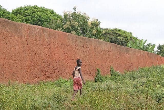
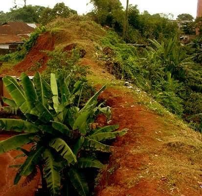
The walls face challenges from urban expansion, drainage projects, and quarrying. Some of the walls have been filled in, built on, or used as refuse dumps.
The Benin Moat (Edo: Iyanuwo), also known as the Benin Iya, or Walls of Benin, are a series of massive earthworks encircling Benin City in Nigeria’s Edo State. These moats have deep historical roots, with evidence suggesting their existence before the establishment of the Oba monarchy. Construction began around 800 AD and continued until 1460 AD, involving large-scale manual labour and the repurposing of earth from the inner ditch to build the outer berm. Some traditional sources claim that these earthworks spanned approximately 16,000 kilometres (9,900 mi), enclosing about 6,500 square kilometres (2,500 sq mi) of land, but very little remains today.
The Benin Moat served as defensive structures, with steep banks and a berm to deter invaders. Access to the city was controlled through nine gates. Today, remnants of the moats can still be found in Benin City, although urbanization and land disputes pose challenges to their preservation. Recognized for their historical significance, the Benin Moat was added as an extension to the existing World Heritage Site of the Royal Palaces of Abomey in 1995 (though still awaiting official recognition by UNESCO), and was acknowledged by the Guinness Book of World Records in 1974 as one of the world’s largest man-made structures by length, second only to China’s Great Wall. It was described by Olfert Dapper in his book Description of Africa in 1668 as the Great Walls of Benin.
History Background
The origins of the Benin Moats, also known as the Walls of Benin, cannot be attributed to a single ruler or era. While Oba Oguola played a role in expanding and deepening the moats, evidence suggests that these moats existed before his reign and even before the establishment of the Oba monarchy. Various villages and wards that later coalesced into Benin City may have initially dug their moats for both defensive and boundary purposes. The moat is an example of large-scale engineering characteristic of the Benin Empire. It consisted of a combination of ramparts and intricate moats that encircled the city of Benin City in present-day Edo State, Nigeria.
The earliest phase of moat construction in the Benin Kingdom likely predates the Ogiso kings. Archaeological findings and oral traditions suggest that some moats were in existence before the arrival of the Ogiso rulers. These early moats served various purposes, including socio-political organization, economic activities, and defense.
During the rule of the Ogiso kings, the culture of moat construction continued and likely expanded. Moats varied in their origins and purposes. Different villages and wards within the Benin Kingdom had their moats, often constructed for distinct reasons. The Ogiso kings contributed to the development of some of these moats, maintaining control and organization within the kingdom. With the transition from the Ogiso kings to the Obas, the moat-building tradition persisted. Obas like Oba Oguola and Oba Ewuare re-dug and deepened some of these structures. The moats associated with the Benin Kingdom today, particularly the inner moat crossed during Obas’ coronation, might have been deepened during Oba Ewuare’s reign in 1440 AD. Oba Oguola, who reigned around 1280 AD, also played a role in moat construction.
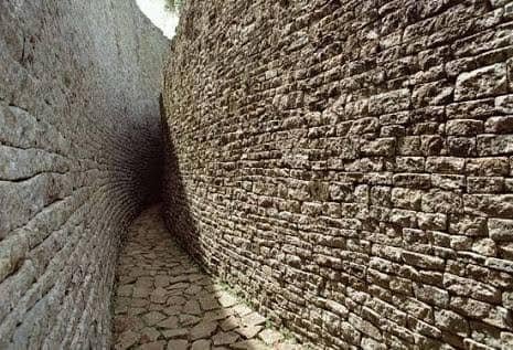
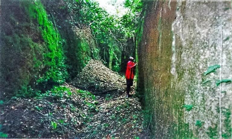
Manual labour was the sole means of construction, precluding the use of modern earth-moving equipment or technology. Earth excavated to create the inner moat was repurposed to build the external ramparts (outer walls). These walls varied in size, from shallow traces to towering structures reaching up to 20 metres (66 ft) in height. The length of the Benin Moat ranks it among the most extensive earthworks in history.
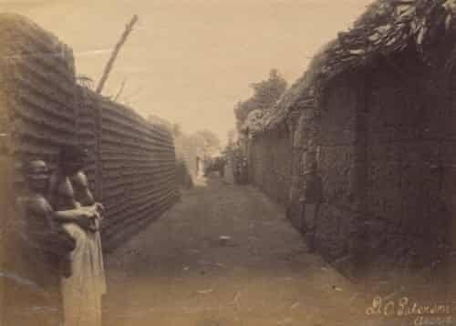
The moats, vigilantly guarded, functioned as effective defensive lines. They exposed invaders attempting to breach the city, resulting in their capture or meeting fierce resistance by Benin soldiers. The steep earth banks posed an obstacle to invaders, who risked burial in sand avalanches. The towering walls discouraged climbing, making invaders targets for Benin soldiers armed with spears and poisoned arrows. The outer walls provided an additional layer of protection, effectively shielding the city. Strict access control was maintained through nine gates in the city walls. The inner wall, approximately 10 kilometres (6.2 mi) long, encircled vital areas, including the Royal Palace and chiefs’ residences. Beyond the inner wall lay a broad ditch, matching the wall’s dimensions. Access through this fortified earthwork required payment of a toll, contributing to the city’s reputation for safety by subjecting visitors, including traders, to thorough scrutiny.
Urban core and protective moats
The heart of Benin City’s historical landscape under the Kingdom of Benin covered an area exceeding 7 square kilometres (2.7 sq mi). It included the residences of the Oba (king), nobility, and indigenous inhabitants. The city’s layout revolved around two perpendicular streets: the principal sacred king’s palace passage extending from the palace to the east, and a cross street connecting the King’s Square to Oba Market, where slaves and ivory were traded. The city’s various communities extended along these streets and other minor ones. The Benin Moat, possibly originally over thirty-five feet in width, surrounded the city and acted as a protective barrier. The moat maintained a consistent depth, an average width exceeding thirty-five to fifty feet, and a length over 13,000 miles (21,000 km). There were two distinct sections of the moat: the primary moat around the urban core and the sacred palace, and a secondary moat constructed later, encircling an area to the south. These moats were complemented by a defensive wall constructed of limestone blocks. Together, the moats and walls constituted defenses.
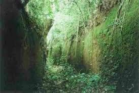
The British punitive expedition in 1897, which heavily damaged the Benin Moat, and the expansion of Benin City has encroached upon and obscured remnants of the rural earthworks. Additionally, some locals have repurposed these materials for construction purposes. Traces of these ancient moats persist, visible as tree-lined embankments woven into the contemporary cityscape.
The moats encircling various towns and villages in Benin Metropolis historically served as boundaries. In many cases, these moats now encompass multiple villages, leading to complexity in areas like Benin City due to urban expansion and ongoing development for housing and industrial purposes. As a result, some villages assert ownership claims over parts or the entirety of the moat enclosures, citing their longstanding presence in the area, even if it means displacing the original inhabitants. Such claims have sometimes resulted in conflicts and disruptions in the region, where the interests of long-standing settlers have clashed with those of newer, more populous arrivals. Land disputes in the courts often involve clashes between the original owners of Iya or moats enclosures and newer settlers claiming ancestral rights.
Portions of the moats have yielded to residential and commercial development, experienced degradation from drainage projects, and been transformed into refuse disposal sites. Certain sections of the moats, such as the area near Ogba Road, have succumbed to pollution and serve as dumping grounds for waste. Preserving these historical assets necessitates comprehensive programs encompassing documentation, preservation, and vigilant safeguarding.
The Legacy
European explorers first learned of the Benin Walls in 1472 AD when Portuguese explorer Duarte Pacheco Pereira made a brief mention of them during his travels, describing it as a city a league wide and defended by a moat. However, archaeologist Graham Connah later cast doubt on Pereira’s depiction, suggesting that Pereira might not have considered an earthen bank as a wall within the context of his time. In the early 1600s, Dutch explorer Dierick Ruiters also noted the fortifications, describing the earthworks, moat, and well-guarded gate.
One of the earliest accounts of the Walls of Benin was given by Olfert Dapper, a Dutch physician and writer who published a book titled ‘Description of Africa’ in 1668. Dapper never visited Africa himself, but he compiled his book from the reports of Dutch travellers and missionaries who had explored various regions of the continent. He devoted a chapter to the Benin Kingdom at page 495 of his book, where he described its culture, politics, religion, and architecture. He mentioned the Walls of Benin as one of the remarkable features of the kingdom, saying that they were four times longer than the Great Wall of China.
In 1974, the Guinness Book of World Records recognized the walls of Benin City as the world’s second-largest man-made structure by length, following China’s Great Wall. The series of earthen ramparts was acclaimed as the most extensive earthwork ever constructed. In 1995, the Benin Moat, alongside Sungbo’s Eredo, was added as an extension to the existing World Heritage Site of the Royal Palaces of Abomey, but it is still awaiting official recognition by UNESCO.

