

…. Continued from previous post
The History of Timbuktu
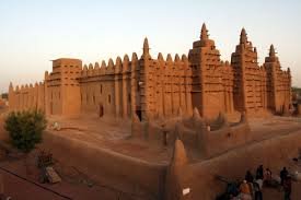
Timbuktu has acquired a reputation in the Western world as an exotic, mysterious place, but the city was once a well-known trade center and an academic hotspot of the medieval world. Timbuktu reached its golden period under the Mali Empire in the 13th and 14th centuries. Distinguished Malian Mansa Mūsā brought great fame to the city by recruiting scholars from throughout the Islamic world to travel there, establishing it as a center of learning. The scholars focused not only on Islamic studies, but also history, rhetoric, law, science, and, most notably, medicine. Mansa Mūsā also introduced Timbuktu, and the Mali Empire in general, to the rest of the medieval world through his Hajj, as his time in Mecca would soon inspire Arab travelers to visit North Africa. Europeans, however, would not reach the city until much later, due to the difficult and lengthy journey, thus garnering the city an aura of mystery.
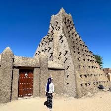
Timbuktu primarily gained its wealth from local gold and salt mining, in addition to the trans-Saharan slave trade. Gold was a highly valued commodity in the Mediterranean region and salt was most popular south of the city, though arguably the biggest asset Timbuktu had was its location. The city is situated nine miles from the Niger River, making for good agricultural land. Its position near the edge of the Sahara Desert made it a hub for trans-Saharan trade routes. Timbuktu also acts as a midpoint between the regions of North, West, and Central Africa. Because of this, Timbuktu developed into a cultural melting pot.
Both Leo Africanus and Heinrich Barth believed the name was derived from two Songhay words: Leo Africanus writes the Kingdom of Tombuto was named after a town of the same name, founded in 1213 or 1214 by Mansa Suleiman. The word itself consisted of two parts: tin (wall) and butu (Wall of Butu). Heinrich Barth wrote: “The town was probably so called, because it was built originally in a hollow or cavity in the sand-hills. Tùmbutu means ‘hole’ or ‘womb’ in the Songhay language: if it were a Temáshight (Tamashek) word, it would be written Timbuktu. The name is generally interpreted by Europeans as well of Buktu (also same word in Persian means ‘where the sun sets’, West), but tin has nothing to do with well.”
Berber origin: Malian historian Sekene Cissoko proposes a different etymology: the Tuareg founders of the city gave it a Berber name, a word composed of two parts: tin, the feminine form of in (place of) and bouctou, a small dune. Hence, Timbuktu would mean “place covered by small dunes”.
Abd al-Sadi offers a third explanation in his 17th-century Tarikh al-Sudan: “The Tuareg made it a depot for their belongings and provisions, and it grew into a crossroads for travelers coming and going. Looking after their belongings was a slave woman of theirs called Timbuktu, which in their language means [the one having a] ‘lump’. The blessed spot where she encamped was named after her.”
The French Orientalist René Basset forwarded another theory: the name derives from the Zenaga root b-k-t, meaning “to be distant” or “hidden”, and the feminine possessive particle tin. The meaning “hidden” could point to the city’s location in a slight hollow.
The validity of these theories depends on the identity of the original founders of the city: as recently as 2000, archaeological research has not found remains dating from the 11th/12th century within the limits of the modern city given the difficulty of excavating through metres of sand that have buried the remains over the past centuries. Without consensus, the etymology of Timbuktu remains unclear.

Like other important Medieval West African towns such as Djenné (Jenné-Jeno), Gao, and Dia, Iron Age settlements have been discovered near Timbuktu that predate the traditional foundation date of the town. Although the accumulation of thick layers of sand has thwarted archaeological excavations in the town itself, some of the surrounding landscape is deflating and exposing pottery shards on the surface.
Results suggest that the site was first occupied during the 5th century BC, thrived throughout the second half of the 1st millennium AD and eventually collapsed sometime during the late 10th or early 11th-century AD.
The Mali Empire reached a steady decline in the mid-1400s, giving rise to the Songhai Empire. However, the city of Timbuktu entered a brief period of rule under the Tuaregs before it fell to the Songhai people. Despite major shifts in power, Timbuktu generally flourished until the Moroccans invaded the Songhai Empire in 1590 and began to occupy Timbuktu in 1591, after the Battle of Tondibi. In 1593, many of the city’s scholars were executed or exiled for disloyalty to the new rulers. This, along with a decline in trade as a result of increased competition from newly available trans-Atlantic sailing routes, caused the city to lose its prominence. In the 1890s Timbuktu was formally incorporated into the French colony of Sudan, remaining under French control until the colony became the independent nation of Mali in 1960.
Today, the population of Timbuktu has substantially decreased since its estimated peak of 100,000 people in the medieval period. The city has suffered from great poverty for several years now, relying on government funding as a means of survival.
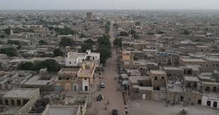
Timbuktu is located on the southern edge of the Sahara 15 kilometres (9+1⁄2 mi) north of the main channel of the River Niger. The town is surrounded by sand dunes and the streets are covered in sand. The port of Kabara is 8 kilometres (5 mi) to the south of the town and is connected to an arm of the river by a 3 kilometres (2 mi) canal. The canal had become heavily silted but in 2007 it was dredged as part of a Libyan financed project. The annual flood of the Niger River is a result of the heavy rainfall in the headwaters of the Niger and Bani rivers in Guinea and northern Ivory Coast. The rainfall in these areas peaks in August but the floodwater takes time to pass down the river system and through the Inner Niger Delta. At Koulikoro, 60 kilometres (37 mi) downstream from Bamako, the flood peaks in September, while in Timbuktu the flood lasts longer and usually reaches a maximum at the end of December. The area flooded by the river was once more extensive and in years with high rainfall, floodwater reached the western outskirts of Timbuktu itself. A small navigable creek to the west of the town is shown on the maps published by Heinrich Barth in 1857 and Félix Dubois in 1896. Between 1917 and 1921, during the colonial period, the French used slave labour to dig a narrow canal linking Timbuktu with Kabara. Over the following decades this canal became silted and filled with sand, but in 2007 the canal was re-excavated as part of the dredging project so that now when the River Niger floods, Timbuktu is again connected to Kabara. The Malian government has promised to address problems with the design of the canal as it currently lacks footbridges and the steep, unstable banks make access to the water difficult.

